Stop posting and cut more trail for the next time I get the draw


 Goat Poker
Stop posting and cut more trail for the next time I get the draw
Thunderstick Moab hybrid longbow T/D 58" 52#@28". Jim Reynolds
Crow Creek Crow Mag hybrid longbow 3/pc 60" 51#@28". Elmer Patton
Field editor @ Journal of Mountain Hunting
 HuntingBC Chump
Oh you know it... after dragging some of his deer up outta hell holes... he's going to learn the pain of hauling down hillOriginally Posted by srupp

No idea yet... I'll find out next week
I thought Ricardo would have had some trails cut last year, or was it the year before? I also keep looking on google earth. There's the one road that goes up the east river and into an old cut block. It get's pretty close to the alpine on the east side of the zone... but knowing the area it's probably grown in.
HuntingBC Chump
www.facebook.com
https://www.facebook.com/warnniklz/v...9464021220387/
https://www.facebook.com/warnniklz/v...9464021220387/
I've never been good at embedding videos... so here's three attempts at hopefully something you can see.
Anyways....
HuntingBC Chump
I started trail up into Dink Mountain. Was not feeling well one bit. I was chumming the trail while I was re-cutting it. It seemed like forever cutting through the trail. I hadn't been that sick since February of 2010. I finally broke into the base of the mountain around 4 in the afternoon. I had a little sit down and took a break. I set up my trail cams in alright spots... I think.
There has been lots of movement where I set up my trail cameras. One was at the base of a granite face. The other was set up on a rock with a whole shit load of shit by it. Fingers crossed.
For the trail cameras, I got 32GB SD cards. But I got the micro SD cards with the adapter. So when I get up there again, I can throw in the SD card into my phone and take pictures. Retrieval of them is my number one priority when I get back up there. Then I want to run one up behind the "Diesel Tanks" now that I know where the pull out is again LOL.
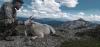
This young billy is the one I believe from post #25. He came and had a peek after I made my little video.
Dink Mountain
On the edge of The Abyss, I still haven't gotten pictures of it from the bottom... maybe next trip up...
I had planned on spending a lot more time cutting trail and scouting. But after throwing up and being feverish, I had to make like safe sex and pull out early. But me and father will be headed back up on Monday!
Last edited by warnniklz; 10-13-2017 at 02:18 PM.
 Member
Good luck Warren, look forward to the story.
KCCO
 Goat Nut
LOL! I'm stealing that for a signature if I can figure out how.
Good pics keepem coming.
Goat Poker
If you come out of your trail and hit the old growth on the right, get to the top and I cut trail through those alders all the way to the top of the highest vegetation on that face. It'll be grown in but should be easy hiking still
Thunderstick Moab hybrid longbow T/D 58" 52#@28". Jim Reynolds
Crow Creek Crow Mag hybrid longbow 3/pc 60" 51#@28". Elmer Patton
Field editor @ Journal of Mountain Hunting
HuntingBC Chump
This run here?

HuntingBC Chump
Our original plan was to head up on the 14th, but I ended up working and putting in a new alternator in my vehicle on the 15th. So Monday morning, me and father left the puddle at 6:30am. Had to stop for timmies and drop some tires off at the fifty to get swapped. We hit rain in Quesnel, some snow east of Burns Lake and more rain right until Terrace. We made a quick stop at Country Wide Sports in Houston for a few things we forgot and Subway in Smithers. We made it to our spot in Terrace by 4:30.
Game face pops!
Burns Lake snow
A whisper of blue sky just east of Terrace... the only blue sky we'd see

HuntingBC Chump
We pulled up to the base of dink mountain, I had enough light to burn up the hill and collect my trail cameras. I thought I had cleared all the grass in front of them. But there was some overhang behind them that triggered them when it was windy. The one camera had over 8000 pictures. But I did manage some...
At the bottom of the hill, I asked my dad "doesn't look like a bad hike does it?"
His reply was "no not that bad"
my comment was "hold that thought"
 Posting Permissions

 Reply With Quote


