Had no idea there's another local app. I have the Hunt Buddy, not sure if it has the feature though.Originally Posted by Foxtail


 Wolfhound
Had no idea there's another local app. I have the Hunt Buddy, not sure if it has the feature though.
HuntingBC Champ
The default view in GE is the best set of images. There's a time line in the top left that lets you pick other times. Newer images may have cloud cover or bad lighting but can still be useful for clear cuts and other "improvements".
Senior Member
Every screenshot of Google Earth is made of a mosaic of imagery. The date in the bottom corner is the age of the oldest imagery you're viewing within your screen. You can access newer imagery by sliding the tab to the newer date markers, but the reason they haven't used the newer imagery throughout your whole screen is because there may have been excess cloud cover or other factor obstructing clear imagery for that area. Play with the app a bit and you'll see what I mean. Basically, what you're seeing is a patchwork of the clearest imagery, but not necessarily the newest.
You can find data from the GeoBC webmap library and just overlay it on your mapping. I turn on "active forest cutblocks" and although the imagery may not show them, the overlay draws the polygons over top so I can see where newer cuts are. Not complicated, but you kind of need a bit of an idea how to use mapping layers and how to import KMLs or KMZs into Google Earth. It's simple enough that anyone putting the time in to figure it out would be able to do so. How quickly things come together for you will be a personal variable.
 HuntingBC Champ
I actually got it by accident while trying to get hunt buddy but couldn't remember the name. Figured since I paid for it, I would give it a chance. It is an amazing piece of tech.
 HuntingBC Champ
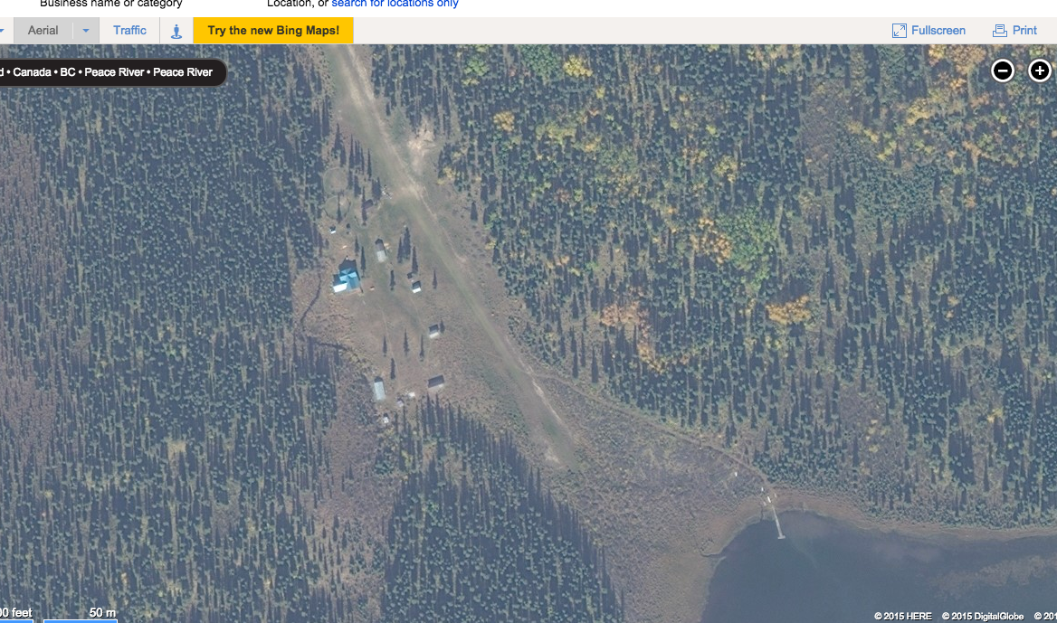
I find I don't get this level of clarity from Bing. I'm not sure why. If I zoom in like this image, there is nowhere as much detail. Is there a trick to getting better results?
Forever a Resident Hunter
Try Vertisee. Way better for northern BC and you can pay for better maps and data.
http://vertisee.mcelhanney.com/
I check here over google earth anyday first for clarity
Get out of the Truck, Off of the trail, and Onto the tracks...
HuntingBC Champ
Can you calculate inclines in degrees? I've been trying to do that. That would be valuable for researching areas for sheep or goat hunting.
Last edited by 375shooter; 10-14-2015 at 09:47 PM.
 He/She/They/Them
Possibly. I have never done it.
If you draw a path on your map and then look at the Show Elevation Profile view of that path it will give you the distance to the target and the elevation of that target.
So theoretically if you have the two sides of the triangle you could calculate the hypotenuse and the incline angle.
From that you should be able to calculate the degree of incline.

Last edited by adriaticum; 10-14-2015 at 10:33 PM.
1. Human over population
2. Government burden and overreach
Senior Member
The elevation profile tells you the slope in % at the adjustable point of analysis (the vertical line you can move to different parts of the profile to get point specific data). From there, just convert % to degrees. The quickest way would be to use an online gradient conversion app.
have fun!
 Old man on a hill
I was keeping this to myself as a bit of a greedy little secret.
http://ge-map-overlays.appspot.com/bing-maps
This will let you see Bing maps on Google Earth. That way you can see which one has the most recent image data.
If an animal is going to die so that I might live, the least I can do is perform the unsavoury deed myself.

 Reply With Quote