Are there different updated versions of google earth avail for use if you choose to pay for the better versions?
at the bottom of the screen it says image date 2004. When scouting logging roads and cutblocks an 11 year old image is a big gap.

 HuntingBC Champ
Are there different updated versions of google earth avail for use if you choose to pay for the better versions?
at the bottom of the screen it says image date 2004. When scouting logging roads and cutblocks an 11 year old image is a big gap.
Site Sponsor
 HuntingBC Champ
Nope. Google Earth Pro is now free, and they don't care about updating imagery for way out in the boonies.
Yup, that coiler is a personal best...
Senior Member
I found if you click on where it says 2004 it opens up a box at the top left and you slide the button to 2014 and the images change most of the time but not all the time.
 He/She/They/Them
You can't use Google earth to give you an accurate picture of the forest.
But it can give you a good picture of the terrain relief and you can calculate distances, inclines and sometimes know if there is water in an area.
Also roads for the most part are marked well.
1. Human over population
2. Government burden and overreach
 HuntingBC Champ
Not true...Originally Posted by adriaticum

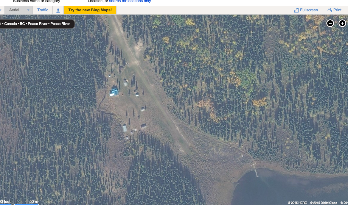
You can get very accurate info off google earth and other maps such as Bing maps. This is a screen shot of an outfitters set-up in the middle of region 7-50 (basically a 45 minute float plan ride to the area). You can actually count the trees in this image!!!
 Swollen Member
Wow is that Bing maps?
He/She/They/Them
Lets rephrase, it's true for most areas actively logged, you can't count on knowing if the area is passable or not.
Or the density and height of trees.
You just have to be on the ground.
Sure trails and camp spots that have been around for a while can be reliably found but I wouldn't trust the images of the forest.
I have had many hiking plans changed when I got to the area and realized you can't walk through it because the bush is so dense or there is tons of beetle kill.
The picture of that area you are showing may be accurate if it's very remote and it's not logged.
Last edited by adriaticum; 10-14-2015 at 12:15 PM.
1. Human over population
2. Government burden and overreach
torque-snorter
lots of more remote areas are not current at all.
most my areas show they are still thick forest when lots of it has been atom-bombed for years.
I use the maps to simply get a better idea how the terrain is laid out, but it still doesn't beat putting boots to the ground.
that's really how I know just what I'm looking at on the maps, because I've walked the whole areas, and now know what I'm looking at.
sometimes you find water sources that you didn't realize were over that next hill, etc.
 HuntingBC Champ
I recommend getting the iHunter BC app for your phone. It has cacheable sat img and overkays the MU's and even shows you the indian bands. I have used it on 3 hunts now and I am more impressed with it each time. Has full regs aswell.
 Member
kluacheezy lake ...that's good quality pic

 Reply With Quote